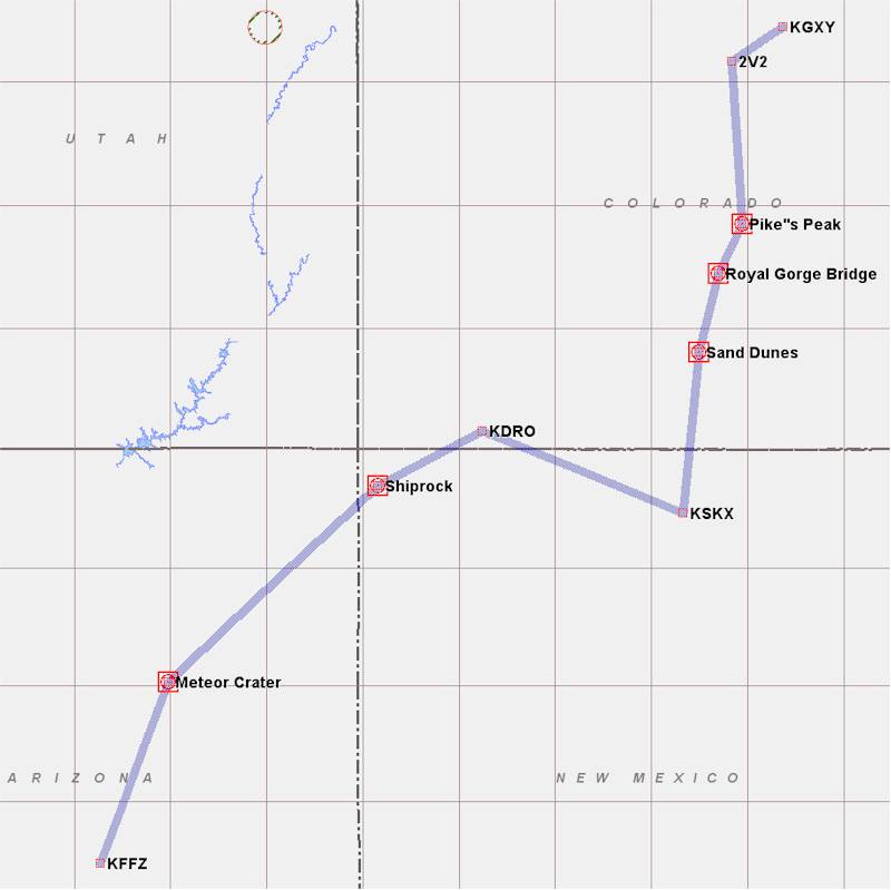
We woke early, since I wanted to beat the heat of the afternoon and avoid the turbulence associated with it. At 6:30 AM, after checking the weather, packing all of our stuff, and loadiing up the car, we said thanks and goodbye to Terri and then Lee drove us to the airport. I packed up the plane with all of our stuff (I think there might have been some room in the back for an M&M (if we had had one), but not much more. I had put enough fuel in the day before for the flight to Taos and on to Durango, but no extra - I wanted to be light taking off from Taos.
After saying goodbye to Lee, we taxied out to runway 34 (the 10K ft. long one) at Greeley (KGXY) and I did my runup. I then made a radio call that I was departing, and just before reaching the runway realized that there was an ag-plane on short final that hadn't made any radio calls. This is why we use the eyeballs - I watched him land in front of us, and then we departed. It was cool - maybe 65 degrees, so the Density Altitude might have been 6000 ft. or so. I would estimate that we used about 3500 ft. of runway before rotating and beginning our climb. We turned to the southwest, and headed for the northwest corner of the Denver class B airspace, climbing to 8500 ft. We headed south, along the western border of the Class B, passing Denver and Boulder, with the front range of the Rocky Mountains just a few miles to our right. After passing the southwest corner of the Class B, we headed slightly eastward, climbing to 9500 ft. We passed just west of the Air Force Academy and Colorado Springs, with Pike's Peak looming 5000 ft. over us to the west.
We then turned southwest through the Airburst MOA toward Canon City, CO, to follow the pass over the Royal Gorge Bridge area into Wet Mountain Valley. As we did this we climbed up to 10,500 ft. This got us past the first range of mountains, and close to the second. After having been there on the ground, it was fascinating to look down at the bridge over a 1000 ft. deep gorge and realize that we had walked across it and looked down through the wooden slats of the bridge into the river below. There's also a tram that takes you down to the bottom of the gorge, so you can look 1000 ft up at the bridge.
Anyway, we headed south down the valley, over Silver West Airport (C08), with the Sangre de Cristo range to our west. We climbed up to 12,500 ft. as we turned west to head through the (apparently unnamed) northernmost pass (the one just north of Mosca pass) over Sand Dunes National Monument. Again, Deanie and I had been there 9 years previously, so we looked down upon the campground we had stayed at and the dunes we had climbed. Very cool from the air.
We descended back down to 10.5K ft after coming through the pass and headed south past Blanca Peak along east side of the wide San Luis valley to Taos,NM (KSKX). At 7091 ft. elevation, this would be the highest airport I had yet landed at - beating Meadowlake near Colorado Springs by a few hundred feet. At 5800 ft long, I wasn't much worried about the landing, although 90 mph IAS at a density altitude of 7700 ft. looks pretty dang fast, but I was a bit concerned about the subsequent takeoff. I called in from about 15 miles north for traffic advisories, and Joe Patterson said "hi, Marc, the winds are calm and there's no one around so you can do as you wish". We chose to land on runway 22, and then we pulled up to the "terminal" building - a small red building with the ops manager's office in it. It was a great 1.5 hour flight.
We had a wonderful visit with Joe (that was the whole reason for heading down to Taos - Joe manages the airport there, and is on the COZY mailing list) - if there's a more hospitable guy on the planet, I've never run into him. Joe had some pastries for us, told us about cool stuff to see in the area, told us what area to avoid on takeoff to ensure that we weren't shot at by the Methamphetamine addicts that live a couple miles further out in the middle of nowhere, and just had a good time. We stayed for about an hour - I think we got ready to leave around 10 AM.
The density altitude was about 8100 ft when we took off, and I rotated after about a 3500 ft. roll. I should have left it on the ground for a few hundred feet more, because the climb rate was pretty anemic for about 10 seconds until we picked up a bit more speed. The area around the airport is dead flat, though - you could fly around at 5 ft. above the sagebrush and not hit anything for miles, so a measly 200 ft./min. climbrate for 10 seconds wasn't going to hurt anything. We climbed up to 8.5K ft. and then 10.5K ft. for the relatively short flight to Durango, CO (KDRO) over a few ridges. About 3 minutes after takeoff, I realized that I hadn't called Don Solomon to advise him of our arrival time, so I'd have to call him when we got there. Both the flight from Greeley to Taos and from Taos to Durango were pretty much as smooth as glass - it was relatively early in the day and the convective warming hadn't kicked in yet. The whole area of Southern Colorado and Northern New Mexico is just so beautiful to fly over, even on a hazy day when visibility was only about 75 miles :-). Us folks from the east coast and mid-west appreciate the visibility even when it's that crappy :-).
 After
landing at Durango, I called Don while taxiing to the tie-down, and he said he'd
be there in about 1/2 hour. I fueled up the plane (since we now had a 9,100 ft
runway, I pretty much topped it off, and then borrowed the loaner car to head
over to the terminal to get Deanie some food. Don met us at the terminal, and we
talked for a while before heading out to the airplane to look it over. Deanie
hung out in the lounge while Don and I looked at the plane - she wasn't feeling
to great, due to the altitude, so she lay down and took a nap for 1/2 hour. I
put in 2 qt oil while I showed Don the plane. He was a bit concerned about size
and fit (he's a big guy), but after sitting in it for a few minutes, even with
my setup for a small person, it was pretty clear that he could fit with some
very minor mods to non-structural or aerodynamic items. I then set up the Oxygen
system so that Deanie and I could use O2 for the flight down to Phoenix - this
would help a lot with her not feeling well.
After
landing at Durango, I called Don while taxiing to the tie-down, and he said he'd
be there in about 1/2 hour. I fueled up the plane (since we now had a 9,100 ft
runway, I pretty much topped it off, and then borrowed the loaner car to head
over to the terminal to get Deanie some food. Don met us at the terminal, and we
talked for a while before heading out to the airplane to look it over. Deanie
hung out in the lounge while Don and I looked at the plane - she wasn't feeling
to great, due to the altitude, so she lay down and took a nap for 1/2 hour. I
put in 2 qt oil while I showed Don the plane. He was a bit concerned about size
and fit (he's a big guy), but after sitting in it for a few minutes, even with
my setup for a small person, it was pretty clear that he could fit with some
very minor mods to non-structural or aerodynamic items. I then set up the Oxygen
system so that Deanie and I could use O2 for the flight down to Phoenix - this
would help a lot with her not feeling well.
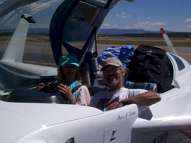
In this picture Don took, you can see Deanie and I, with the mountains in the background looking over the Durango runway. You can also see the mountain of crap completely filling the rear seats of the airplane. I had to stuff Deanie's pocketbook into the back after closing the canopy, or else I couldn't get it closed due to the canopy bulkhead cross member. It's actually pretty amazing what you can stuff into the back of one of these things, especially with soft bags and luggage.
At any rate, we said goodbye to Don around 12:45 PM (a bit later than I had hoped - I was now expecting to get pretty beat up y convective heating on the trip down to Phoenix) and took off. It had warmed up, and the density altitude was about 9100 ft. We were pretty heavy, with full fuel (maybe about 1900-2000 lb.), so I kept the plane on the ground until I was indicating 95 mph. The plane rotated easily, and took about 5 seconds to establish a decent climb rate at about 110 mph IAS. Rotation occurred, even at that speed and density altitude, after about 4500 ft. of roll. Our CG was probably within one inch of the rearmost position, so that helped - a more forward CG would make rotation a lot more difficult.
After climbing, we put on O2 at 10.5K ft. and headed off to Shiprock, about 55 miles away. I'm sure we've all seen pictures of this leftover bit of a volcano in movies - it's just this huge craggy rock sitting in the middle of nowhere. Joe Patterson had pointed out that there are two ridges of rock that come together right at the rock at almost exactly 90 degrees, and that's extremely unusual. From there, we continued on toward Winslow, AZ and Meteor Crater. I had flown over the crater with my parents back in 1970 in a short commuter hop from Winslow to Flagstaff (or vice versa - we were on vacation and I'm sure it didn't make any difference whatsoever which direction we were going), and I had been amazed that the pilot didn't point the crater out to us as we flew directly by it. It's amazing to think, when looking down at this thing that's 1/2 mile across and a few hundred feet deep, that something about 150 ft. across had whizzed down out of the sky and blasted this hole.
From the crater, we then headed on to Falcon Field (KFFZ) in Mesa, AZ, about 100 miles southwest. The whole ride, from Durango down to Falcon Field, was pretty bumpy - light turbulence, but a bit annoying. We never got slammed around, though, or whacked our heads on the canopy. Deanie actually LIKES turbulence - it puts her to sleep. I felt fine, but it did make it difficult to eat a banana and energy bar (why do they make those damn things so sweet?). As we descended from 10.5K ft. over Payson, AZ, I got flight following from Phoenix approach. Even so, we only got one traffic call - the west is pretty damn empty of airplanes, in comparison with the Boston - Washington corridor. As we got down to 3000 ft and started talking to the Falcon tower, I pointed the air vent at my chest since it was getting warmer in the plane. The air coming in was NOT cool. After a 2 hour leg, we landed on runway 22 left, and I popped the canopy open as soon as I could. It was apparently 112 degrees - a far cry from the 60 degrees that morning in Greeley :-). We waited at the air conditioned Executive Aviation terminal with all our stuff, and I called David Greenwood (a builder on the mailing list) to come pick us up - we were going to stay at his house for a few days.
Dave picked us up about 20 minutes later. We stopped to pick up a couple of bags of ice for the BBQ later, and then got to his house. Dave has a gorgeous house for himself, his wife Barbara, and their three kids and two German Shepards. He put us up in their guest suite over the garage - it's palatial. Visit Dave if you get a chance :-). We set ourselves up at their house and went in the pool for an hour - the water temperature is 91 degrees, which feels great in comparison to the 112 outdoor temperature. Because the humidity is so low (around 10% or so), the water evaporates off your skin so quickly that you actually feel cold when you get out of the water (for about 3 minutes until you're bone dry, and then you're roasting and ready to go in the water again). Strange place :-). Anyway, after the dip, we rested for an hour - it had been a long day - and then the BBQ/party started at 6-9 PM. The following folks showed up:
We all had a great time looking at Dave's project, yakking about airplanes (is there a theme here?) and eating great food the Dave and Barbara had made and that other folks had brought. The party broke up around 9 PM and Deanie and I retired to our presidential suite to relax and go to sleep after a long day. I called my friend Claude to find out if he had shipped all that stuff that I couldn't pack in the plane (he hadn't yet :-( ). Then we read for a bit and went to sleep.
Tomorrow - catch up on paperwork/computer work, relax by the pool, and check
out the Phoenix area on a 110 degree day.
| [Zeitlin's Cozy MKIV Information] [Zeitlin's Cozy MKIV Logbook] [Cozy MKIV Information] |
Copyright © 2005, All Rights Reserved, Marc J. Zeitlin