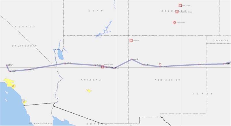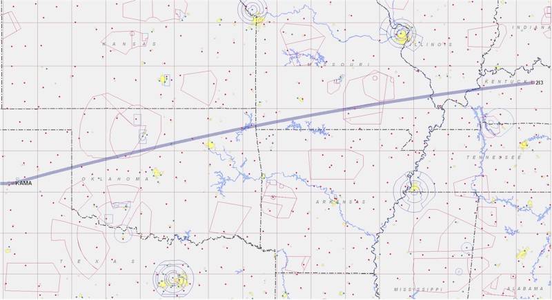
We pretty much retraced our steps on the way back - heading over the Ohio and Mississippi rivers into Missouri and Arkansas, then into Oklahoma. We climbed up to 8500 ft. and then 10.5K ft for cloud avoidance, and traveled a couple hundred miles over some broken cloud decks, with glimpses of the ground on occasion. A couple of times there were some larger buildups, but rather than climb over them at 12.5K ft or 14.5K ft, with the ensuing stronger winds and need for O2, we were able to divert a few degrees to the south in all cases to avoid them. Just past Tulsa and Oklahoma City, we diverted south around the southern end of the frontal system that we had seen in the weather check, and popped out into severe clear weather just prior to crossing into Texas. The winds weren't any stronger up higher - about 30 kts. of almost direct headwind - but since we were burning far less gas at 10.5K ft. than at 6500 ft (7.8 gph vs. 9.5 gph) while only losing about 10 kts. of TAS, the fuel computer and fuel level gauges were now telling us that we'd pull into Amarillo with about 5-7 gallons of gas. Good enough - that was a 45 minute reserve at our current fuel burn, and there were numerous airports along I-40 in Texas on the way to Amarillo.

We were cleared for a landing at KAMA by Amarillo Approach and landed in a 20 kt crosswind (about a 10-12 kt. crosswind component) on Runway 31, about 3 minutes after a 737 had taken off. We touched down after 5.3 hours in the air, for an average GS of about 140 kts. After taxiing to the FBO/gas pumps, we went to the "English Field House" restaurant to get some lunch and watch some other aircraft taxi in. We then fueled up, checked the oil, preflighted, and headed out to take off on the 13.5K ft. long runway 04 at KAMA. Right before us, an army learjet took off and apparently hit a bird at about 500 ft - we could hear them talking to the tower and approach about it, and they were pretty shook up, although they didn't seem to have damage that required a return to the airport. We took off, turned west, and climbed to 10.5K ft., following I-40 toward Tucumcari, etc. Again, the winds were averaging 25-35 kts, so our GS was miserable, but we were getting about 17 NM/gal in any case.
I had been playing with the Dynon engine monitor all along, trying to decipher EGT's and CHT's, which seemed to be extremely dependent on climb angle, IAS, throttle and mixture settings, as well as the phase of the moon. I eventually determined, using the "Lean Mode" of the monitor, that cylinders 1 and 2 were peaking far earlier than 3 and 4 as I leaned the engine during cruise, and that this was the single largest factor in determining the CHT's that the engine would settle at. I could play with the baffling until the cows came home and it wouldn't change the fact that two of my cylinders were well past peak EGT while the other two were just peaking and so had far higher CHT's. I couldn't lean much more, because 1 and 2 would start missing as they got too lean. At 10.5K ft and a density altitude of 11.8K ft, I wasn't going to hurt the engine (at about 60% - 65% power), but I'm not sure what I'm going to be able to do to even out the EGT and concomitant CHT issue. Suggestions are welcome.
At any rate, we passed Tucumcari, Santa Rosa, Albuquerque, Grants, Gallup, Holbrook, Winslow, Flagstaff, and Kingman, with the miles and views rolling by - another 120 NM visibility day (once we passed Amarillo). We listened to the airliners complain about turbulence up high, and saw a few planes following I-40 going the other way. As we passed over Laughlin, NV and got toward Barstow, CA, I changed course to cross through the Edwards AFB airspace, since the restricted area was cold. It was getting dark and that would cut 10 minutes off the flight. As we passed over Edwards with the sun setting, we could see the lights of Tehachapi in the distance. We cancelled FF, tuned in Tehachapi's test AWOS, determined what runway we'd land on, and headed in. After 5.7 hours in the air, we landed with about 7 gallons left in the plane - over 45 minutes of reserve. I think with balanced cylinders and good leaning, 7 hours in the air would be achievable up high.

We put away the plane, and drove to the house. It was almost exactly 13 hours door to door, from Rough River, KY to Tehachapi, CA, with one stop included. I challenge anyone to do that on a commercial flight - even with a 20 - 30 kt. headwind, this airplane is nothing short of amazing - only one stop in 1540 NM (great circle distance - actual distance 1602 NM), with an average GS of about 145 kts.
We had a great time. I very much enjoyed seeing folks that I knew, meeting folks that I didn't, and giving rides to folks that wanted them. I don't think that I'll be flying to RR every year - 21 hours in the air is a lot of time/expense for a two day experience, but every few years will probably be doable. I heartily recommend that everyone on the west coast (and east) make it to the Columbia fly-in in May, at O22 in CA. It's a great alternative (and very similar) to RR.
And while Tom Staggs won the "one-way" distance award, beating Dennis and I by about 125 miles, coming to RR from the Seattle area, I believe that far and away we won the "direct round trip" distance award, since Tom was going on to other east coast/mid-west flight destinations, while we were just going home :-).
Thanks to everyone!
| [Zeitlin's Cozy MKIV Information] [Zeitlin's Cozy MKIV Logbook] [Cozy MKIV Information] |
Copyright © 2007, All Rights Reserved, Marc J. Zeitlin