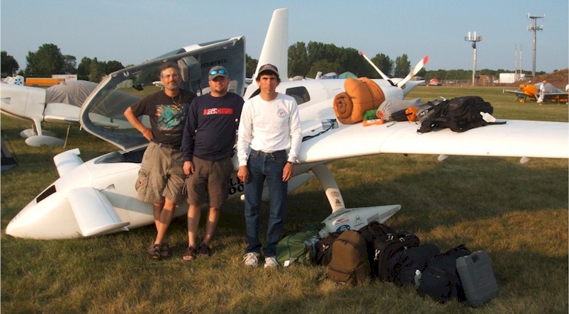
I got back to the plane around 7:30, and Danny, Kevin and I began breaking camp and packing up. Here's a picture of the three of us with all our stuff.
It was easier getting everything in the second time, because I knew that we had done it once before (even though we had picked up a few things along the way).
By 8:30 AM we were done packing, the front was getting closer, the wind was picking up, and there was a long line of planes waiting to get out. We said our goodbyes to everyone around us and climbed in. After realizing that I couldn't get to the Steve Campbell re-adjusted rudder pedals, I got back out and put them back into my midget flyer position. We cranked up at about 8:35 AM and taxied out, getting to the back of the line. The ground crews were sending EVERYONE to runway 27, I suppose due to the winds from the west, but geez, with 2 10K ft N-S runways and a 15 kt. crosswind, everyone should be able to takeoff no problem.
Anyway, we waited about 10-15 minutes, watching the line progress REALLY slowly, and then realized that they had opened the 36L runway for departures (all this while the front is covering OSH and 10-30 miles to the south, and a light rain came and went, but it was still VERY VFR). Due to the castoring nosegear and great turning radius of the plane, I was able to spin around without crashing into the Lancair 4 in front of us and get in line for 36L. Another 10 minutes and we were in the air.
Curt, who was about 8 planes ahead of us, apparently got stuck in the line for 27 and had a 45 minute ground wait for takeoff.
Anyway, we were off the ground at 8:59 AM local time. We headed south at 1000 AGL, avoiding the darkest clouds, and popping out from under the front about 1/2 way to Madison. We hit a few light rain showers along the way, but nothing serious. We climbed to 4500 ft and headed west, then up to 6500 ft. Called Madison approach for Flight Following, but they dropped us after 10 minutes without a handoff. Finally got through to Chicago Center, and got a couple of traffic calls along the way to KBFF - Scott's Bluff, NE. We had a 15 kt. headwind pretty much the whole 4.5 hours to BFF, and averaged about 152 kts. Once again, flying over Wisconsin, Iowa, and Nebraska is like watching paint dry, although we were pretty amazed at how desolate mid-Nebraska is - lots of abandoned farms reverting to grassland.
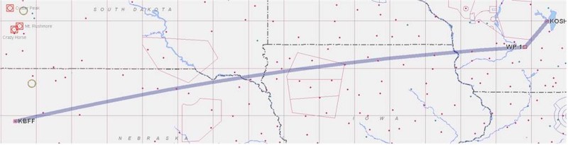
BFF's got a new terminal with a very nice restaurant, so we got lunch there and I charged up my camera while we were eating. We all called family to assure everyone that we were about 1/2 way home and safe. We gassed up, added a quart of oil, checked the weather again, removed the tape from the canard cover/fuselage junction which had started to come off and buzz during the morning flight, and got ready to go.
It was HOT - about 95F on the ground, and still 76F at 8500 ft. as we started west. We were flying almost due west, out of Nebraska over southern Wyoming - a somewhat more interesting landscape. I had chosen a route that COULD be flown at 8500 ft., although that's only 1000 - 2000 ft. AGL, and out of radar contact. We climbed up to 10.5K ft. for ground clearance and to stay on flight following. It was light chop mostly, and Danny and I put on the O2 to keep our heads clear at altitude with the somewhat nausea inducing bumpiness. It definitely helped, although we killed the bottle before getting home. We flew over the Medicine Bow VOR, and pretty much followed Interstate 80 through the relative desolation of southern Wyoming. Interesting countryside - very high desert, mostly. There were mountains both north and south of us, but they were pretty far off.
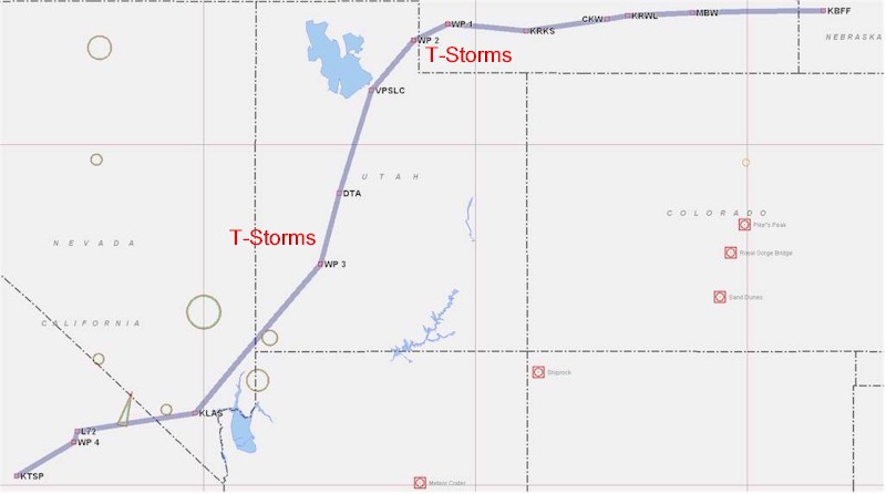
Listening to Center, we realized that there were some T-storms in the Ft. Bridger area, and that folks were detouring around them, even up at 30-40K ft. It sounded like 10-20 miles north of Ft. Bridger was clear, so we headed a bit more north than planned and were able to skirt the storms, no problem. We did see a few lightning bolts 20 miles south of us on occasion. We started turning south toward Salt Lake City north of Evanston, and came over the ridge to SLC. We then turned almost due south, flying over the Delta VOR and down to Milford, UT. There were T-storms about 40 miles to the east of us, and one just over Milford, so we detoured about 10-15 miles east to get around it. Again, more lightning. Out west, in contrast to the storms I'm used to back east, the storms are isolated, with clear blue sky between them, and visibility is still pretty good (30-50 miles), so it's relatively easy to avoid them.
We stayed at 10.5K ft., since our detours were carrying us over ground that was higher than planned. The sky was clear between Milford and Las Vegas, so we motored on. We heard LOTS of detouring of commercial airliners around the T-storms, which apparently reached well up into the 40's - 50's K ft.
Clouds reappeared around Las Vegas, so we initially descended to 9500 ft. to go under them and still stay above the LAS Class B airspace. We then climbed back up to 10.5 K ft over the ridge to the west to get back on the correct VFR altitude for westbound flight, but got back into the haze/cloud layer. We climbed up to 12.5 K ft. as we approached Shoshone, CA, but the clouds then dissipated and we descended back down to 8.5 K ft after about 5- 10 minutes. We were in the home stretch - 45 more minutes and we'd be home. We headed west over the south end of Death Valley and the Panamint Valley to Trona (L72), then turned south through the "Trona Gap" and back south west to Tehachapi.
After a 5.7 hour leg - by FAR the longest period of time I've spend in the airplane, we landed with about 8 gallons remaining in the tank - still more than IFR reserves - after burning anywhere from 7.5 - 10 gal/hr., depending upon altitude, turbulence, and oil temperature adjustments.
The two legs totalled 10.2 hours in the air, and with the lunch stop, it was about 12 hours door to door - OSH to house in Tehachapi. The best I could find, from Appleton to Bakersfield, was 8 hours with two stops. Then, add an hour of driving on each end, with a 1-2 hour wait to clear security. Huh - just about the same time, to go 1471 NM, great circle distance - about 2/3 of the way across the country.
Pretty impressive :-).
So, another great OSH. I personally gave rides to 8 people, Curt gave rides to 5, Richard Hughes gave 2, and Mark Beduhn gave 2. The BBQ's, weenie roasts, and dinners were great, the forum went well, we didn't get wet in the tent, and other than the close call on landing, everything went relatively smoothly. I got to find my endurance limit in the plane, too :-).
I don't know that I'll be staying the whole week next year, but I'll definitely be going back!
| [Zeitlin's Cozy MKIV Information] [Zeitlin's Cozy MKIV Logbook] [Cozy MKIV Information] |
Copyright © 2006, All Rights Reserved, Marc J. Zeitlin